Friday, August 14, 2009

Day 40 Plan

Destination: Finish Line
Distance: ~15km

Leave Midland and cross back over towards the finish line in Waubaushene or Victoria Harbour to complete the trip, depending on where I started from. My Mother and Brother both currently reside in Victoria Harbour.


Day 39 Plan

Destination: Midland
Distance: ~20km

Not sure if I will stop here or not, I went to high school here and been so many times I have no real desire to make the trek down into Midland Bay, if my paddle buddy is with me then I will, just to hit the local bar, camping is fairly limited on this stretch but I do have family here as well.


Day 38 Plan

Destination: Penetanguishene
Distance: ~20km

This is where my mother grew up, I have family on the water and will stop in for a visit. My uncle on my Father’s side bought the house from my grandfather on my Mother’s side. Still the only cottage/home growing up that had an elevator from 1st to 2nd floor, we had a hoot as kids. My uncle has transformed the place into quite the cottage and glad he kept the elevator.

Also would not be right if I didn’t stop in at the World Famous Dock Lunch, best burgers in the world, Webbers has nothing on a good Dock Lunch hoe down.


Day 37 Plan

Destination: Awenda Park
Distance: ~10km


Day 35-37 is a little up in the air, will take trips out to the 3 islands off the coast, Christian, Beckwith and Hope. Some great camping spots, been many times by boat and it’s an amazing area. Hope to make it out to Giants Tomb as well but might do that on stage one as I pass by going north.


Day 36 Plan

Destination: Thunder Beach
Distance: ~20km

This is where my Father grew up, my grandfather owned the Ice Shack and rumour has it made moonshine (unconfirmed) although my father did have a huge BBQ and with a few minor tweaks it became a Still. My first experience with alcohol was with Moonshine and to this day, my most favorite drink mixed with pink lemonade, haven’t had in years. Both my Grandfather and Father have passed on and I’ve heard there are still a few bottles around somewhere from their last batch, one day I will find it.


Day 35 Plan

Destination: Lafontaine
Distance: ~20km


Starting to get into very familiar water now, I am from a very large family (very large) my great grand parents had over 10 kids or more and each of those had 10 kids or more, etc. etc., I have family I have never met and probably wouldn’t know them if they passed them on the street. Many are from this area and my father group up not far from here in Thunder Beach.


Day 34 Plan

Destination: Blue Water Beach
Distance: ~25km

Not a big fan of Wasaga Beach at the best of times, hope it will be a weekday when passing through, too many “city folk”, something like 50-100k on a weekend and it’s just insane, that’s the worlds longest fresh water beach for ya. Thinking I will pass right through. Maybe stop in at the Nancy Island Historic Site and check out the wreck of the Nancy. A British Schooner during the War of 1812.


Day 33 Plan

Destination: Collingwood
Distance: ~20km

Sure Collingwood Harbour and the Island Lighthouse, other than that, been to Collingwood so many times I think I just want to get in/get out quickly.


Day 32 Plan

Destination: Thornbury
Distance: ~20km

I think Cragleith Park is in this area, closer to Collingwood, not sure if better to stay in Thornbury or at the Park, either will work just fine.


Day 31 Plan

Destination: Meaford
Distance: ~20km

Have an old friend in Meaford who I haven’t seen in a long time, might stop in for a visit if she is around, she’s a Lush so one can never tell.

Did you hear that Karen (I know you followed along last trip) hook us up with food,drink and place to crash, would be great to meet the family too finally.


Day 30 Plan

Destination: Some Point (Unknown Name)
Distance: ~30km

No idea where this is other than not enough to paddle to the next “known” place, will have to find a place to camp along the way.

Only issue is that this is where the Meaford Tank Range has an operating Canadian Army live artillery training ground and they fire into the water. There are boundary restrictions along the entire area. Still have to figure that one out.


Day 29 Plan

Destination: Owen Sound
Distance: ~30km

Would like to take the hike up to Indian Falls and West Rocks. Find camp spot (Hibou Conservation area maybe) even hotel room, hmmm.


Day 28 Plan

Destination: Big Bay
Distance: ~20km

Not sure about this one, might go right on through to Owen Sound, will have to check weather conditions and camp site options, not sure what’s here to see.


Day 27 Plan

Destination: Wiarton
Distance: ~20km

How can you not stop in and see Wiarton “Willie”, depending on how hungry we are at this point, he better run and hide from more than his shadow. Here little groundhog, here boy!


Day 26 Plan

Destination: Hay Island
Distance: ~30km

Friend Mike’s family owns this Island, it’s like the largest privately owned Island in Canada or North American or something. Complete with Heli-Pad, landing strip and 50km of named roads. If Mike is around will definitely be stopping in.


Day 25 Plan

Destination: Lions Head
Distance: ~30km

Down through Dyer’s Bay (stop and see Devil’s Monument) then down to Lions Head, think you can camp at McKay’s Harbour.


Day 24 Plan

Destination: Cabot Head
Distance: ~15-20km

A lot of exposed shoreline in this area and some of the most dangerous water potential due to the serious lack of any shelter. Make it into Wingflied Basin, not sure if allowed to camp here or not, will have to do a little more research.

Check out the Cabot Head Light house and the Wreck of the Gargantua.


Sunday, August 9, 2009

Day 23 Plan

Destination: Bruce Peninsula National Park
Distance: ~15-20km

Lots of things to see along this section, Indian Head Cove, the Grotto, Overhanging Point, Halfway Rock Point to name a few.

Most likely camp at Storm Haven, I think the campground at Cypress Lake is too far inland.


Day 22 Plan

Destination: Flowerpot Island
Distance: Not Important

Spend the day exploring Flowerpot Island off the coast of Tobermory.

Camp on Flowerpot Island at Beachy Cove and hike up to the lighthouse. Also home to the oldest living tree in North America, 1800 year old cedar.


Day 21 Plan

Destination: Fathom Five Marine Park/Russel Island
Distance: Not Important

Leisure day to start stage two, exploring the 16 islands that make up the Marin Park, 20 different sunken ships in this area and a lot of diving activity.

Will camp out of Tobermory.


Stage 1 Plan Complete

As mentioned, can’t take enough time off work consecutively so will need to do this trip in 2 stages.

The plan is to reach Tobermory in stage one and then complete the trip at another time.

Killarney is just as good a place to stop and closer to the half way point, also leaves a few extra days for comfort if needed. Downside is that I have to be picked up again and I think Tobermory is more convenient than Killarney.

Also depends on Weather, won’t be able to wait for good weather at the end of the trip and can’t cross the 13km gap in remotely iffy conditions, may just take the chi-cheemaun across and get picked up from there.

Then for stage two, take it back across and start where I left off.

Day 20 Plan

Destination: Tobermory
Distance: ~25km

If all goes as planned, will now be in the Bruce Peninsula and the homeward stretch. This is the only real open water crossing required in the whole trip.


Day 19 Plan

Destination: Fitzwilliam Island
Distance: ~20km

This is the last stop before crossing the chasm!


Day 18 Plan

Destination: Manitoulin Island Day 2
Distance: ~25km

They don’t call this the largest fresh water island for nothing.


Day 17 Plan

Destination: Manitoulin Island
Distance: ~25km

At this point start looking out for the chi-chemaun.


Day 16 Plan

Destination: Explore Killarney
Distance: Not Important

There are many things to see in Killarney, Collins Inlet, Philip Edward Island, George Island and the Foxes.


Saturday, August 8, 2009

Day 15 Plan

Destination: Killarney
Distance: ~45km

This is the longest paddle day of the trip, there is very little between French River and Killarney and mostly Indian Reservation land. Might have to split into two days depending on weather conditions.


Day 14 Plan

Destination: Explore French River
Distance: Not Important

Visit Dead Island where the native Indians buried their deceased. Bustard Islands and Outer Fox Islands, probably enough here to do a few days exploring, hopefully will have gotten to French River early enough on Day 13 to explore a little on both days.


Day 13 Plan

Destination: French River
Distance: ~15-20km

Lots to see in French River and if I do nothing else, the trip to Bustard Islands, want a picture of the three lighthouses.


Day 12 Plan

Destination: Explore Henvey Inlet
Distance: Not Important

Explore around Henvey Inlet, Churchill Islands and over to One Tree Island. Mostly crown land so will find a camping spot on wherever the wind takes me, so to speak, the wind takes me west and it’s a lot of open water.


Day 11 Plan

Destination: Explore Britt
Distance: Not Important

Explore around Britt, Duffy Island and the Lighthouse, Cunningham Islands and work way over to Champlain Islands near Henvey Inlet for another day of exploring.

Day 10 Plan

Destination: Britt
Distance: ~30km

Not much between Pointe au Baril, either have to camp somewhere along the way or just do the 30-35km and get to Britt and take a couple relaxing days.


Day 9 Plan

Destination: Pointe au Baril
Distance: ~25km

Cross over to McCoy Islands from Mink Islands and then into Shawanaga Inlet up to Point au Baril.

Ex-wife has and her family have many cottages in this area, if she is there I will most likely stop in for a cold beer. Don’t think the kids will be there though as they will most likely be at camp in Algonquin at the same time.

Remember when I posted about bears and rattlers? This summer my 9 year old ran into a bear walking the 30ft from the sleeping cabin to the main cottage. Heard many a story about bears in this area and remember the hunters going out to shoot some habitual ones. Also remember coming across more than a few rattlesnakes around the cottage.

Beautiful area and also plan on taking a trip to the island which holds the barrel where this place gets its namesake.


Day 8 Plan

5km crossing from Franklin Island to the Mink Islands, spend the day paddling and exploring the Mink Islands and should be around 15-20km.

Camp on one of the smaller islands on northern tip of the Mink Islands.


Day 7 Plan

Destination: Franklin Island
Distance: Not Important

Short hop and a skip from KillBear, will explore Snug Harbour and Franklin Island, camping on the south west shore of Franklin Island.

Day 6 Plan

Destination: Explore Parry Sound
Distance: Not Important

Not sure if I will make it into Parry Sound proper but will be exploring Depot Harbor and surrounding area of KillBear park.

Will either base camp from Killbear or head out to Snug Harbour or Franklin Island

Old pic of Depot Harbour:

Day 5 Plan

Destination: Killbear Park in Parry Sound
Distance: ~25km

Should be a fairly straight forward paddle to Killbear park from Sans Souci. Will be taking a few days to explore this area as there are so many things to see.

Day 4 Plan

Destination: Explore Sans Souci
Distance: Not Important

Explore the islands around Sans Souci and Moon River, primarily the Wreck and Moon Islands.

Lots to see and do, will be a casual day and any paddling will be about exploring the islands. Might even leave camp setup and just go back to the same sight for sleep that night.

Day 3 Plan

Destination: Sans Souci
Distance: ~30k

Plan to leave early in the morning from Cognashene to arrive before dinner and setup camp, possibly over to Henry’s for Dinner.

There are many islands in this area to setup camp.

Day 2 Plan

Destination: Coganshene
Distance : ~15k

Have family and friends in this area and will take time and wander through the many islands and explore.

Relatively short paddle day and will end at Doug’s cottage at some point and will setup camp on the way through.

Sure my brother will be there with the boat, again teasing me to just dump everything into the boat and head out for trip in style, think i would steal Doug’s scoot first…. Now that would be fun.

Day 1 Plan

Destination: Beausoleil Island
Distance: ~25k

Launch point will be either Waubaushene or Victoria Harbour at the southern tip of Georgian Bay.

From there will head out to the east around Moore’s point and into the inner channel to Honey Harbour and over to Beausoleil Island.

Plan on doing some exploring around the island and eventually end up at Honeymoon Bay and setup camp for the night.

I grew up in this area so have been here many times, noticed in previous trip, things look different passing by at 5km an hour in a kayak so don’t want to just blast by because it feels familiar.


Animals

Bears

This is the part that makes me more nervous than anything else in this trip.  I don’t like bears and chances are pretty high that I will have a bear encounter of some sort, this is bear country after all and everybody has a story of some sort. 

Know how to take all appropriate precautions at camp, how to look for bear presence,  how to react when you encounter a bear and how to read bear behavior, pretty much all I can do to prepare, still don’t want it to happen.  Have my bear bangers and looking into bear spray, heard you can’t use them in Ontario, will have to check. 

I have this picture in my head of being woken up on some remote island by a bear who swam out looking for berries and found my skinny ass sleeping and looking awful tasty. 

And no, fact that there have been only about 3 bear deaths in Ontario since the turn of the century doesn’t provide much comfort.   At least we don’t have Grizzlies. 

Rattle Snakes

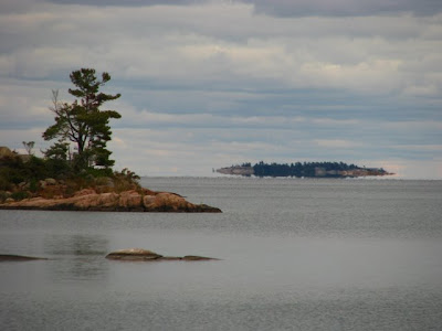
They don’t scare me much, I’ve come across many in Georgian Bay, yah of course, hearing that rattle can be unsettling but they don’t pose much of a problem as long as you pay attention and just let them move on their merry way.  Going to be a lot of camping on rocks and getting out on rocky shorelines,  need to be careful and pay attention is all.  

My only concern would be getting medical attention quickly in the unlikely event I get injected, there are many serious problems (including death) that can occur from a bite from one of these guys, especially if you get a full dose of venom.   They are known for dry bites without injecting venom which is why people assume they are harmless, not the case and you are in trouble if you don’t get to a place that can treat it properly.

On a related note,  wake up Ontario Government, they stopped funding hospitals to store Anti-Venom and as a result hospitals are at an all time critical low.   Parry Sound which treats more snake bites than anywhere in Ontario ran out this august and had to quickly get some from Peterborough Zoo to treat a patient,  leaving only 5 vials at the zoo.  requires at least 12 to treat a snakebite and usually more.   At a cost of 20-80k for treatment. 

Food

Not much will change from what I packed on the previous trip, just need more of it and have to pack in bear proof containers. 

There are places along the way to re-supply but not as frequent as on the Trent. 

Henry’s at Sans Souci is all I can say!  Can’t wait.

Camping

There are thousands of places to camp in Georgian Bay but gone are the comforts of having a nicely manicured lawn at a public lock with washroom access.

A lot of camping will be wherever it can be found, rocks, beaches, islands etc..  A lot more effort than throw up a tent on flat grass.

I enjoyed the setting camp part very much so look forward to finding places along the way. 

There are a few Provincial Parks along the route and a lot of Crown Land, with Crown land you can camp on for free if a Canadian citizen.  

Remote

There are sections of Georgian Bay, especially in the north/east which are fairly remote, even in cottage country, during the week it’s fairly isolated. 

Trent Trip was a walk in the park compared to this, there was really no remote areas, Trent Waterway passes right through cottage country and at the locks each evening there are many people to socialize with.   On Georgian Bay, might be days without seeing another person.

Cell Phone coverage also is extremely limited a number of areas, if something happens, options may be limited and ability to be rescued is measured in hours/days not minutes.

This is the biggest reason I would like a paddle partner on this one, if something happens then I have someone else there to deal with the situation.

Expect the best, plan for the worst!

Friday, August 7, 2009

Weather

Georgian Bay is notorious for quick and sudden changes in weather,  especially wind and storms,  this could be an issue with 200x80km of open water to pick up speed, the waves can get astronomical.

Also have been water spouts, like tornadoes on water, have only heard of a few though and you can see them forming.

The islands along the eastern shore should provide some protection but have to now worry about the numerous shoals that lie just under the surface of the water.  

Western shore has almost no protection.

Will need to be extra extra careful and mind the weather forecast religiously.  On the Trent trip I usually listened in the morning and evening, will have to keep my VHF handy and monitor frequently.

Navigation

The Trent Waterway required little or no navigation skills, just follow the yellow brick road, I didn’t bring maps and while I had my Blackberry GPS, rarely touched it for navigation. 

Georgian Bay, along the Eastern Coast requires good navigation skills, there are so many islands you can literally get lost in them and go in circles.

I will need handheld GPS, Marine Maps and good compass,  can’t rely Blackberry for GPS as the cell phone coverage is spotty and non-existent in many areas.

Route

First, Georgian Bay is absolutely spectacular and excited to see every part of it and the various geographical differences and the history.

In a lot of ways, the route through Georgian Bay is much easier in terms of open water, There is only one major gap to cross and everything can be minimized by following the shoreline if need be in iffy weather conditions, I don’t have to cross a Simcoe, Balsam  or a Rice Lake and be hours from shore.

However, I have no option other than to cross between Manitoulin Island and Tobermory, a distance of about 15k.  Not huge but requires absolutely pristine conditions,  hundreds of miles of Lake Huron on one side and open Georgian Bay on the other, don’t want to be caught out there with a storm brewing or big waves. Can be done by island hoping across which limits open water to max 7k in any one stretch.

More shipwrecks in this area than anywhere else in the Bay for a reason and is also a shipping lane, will have to watch out for freighters and the Chi-Cheemaun.  

The western shore is predominately Niagara Escarpment bluffs with very little shelter from the weather, almost no islands to protect against like the 30,000 islands down the eastern shore.  There is also an army base around here somewhere that does mortar practice into the lake,  this is protected boundary waters and unless I want to go 5 miles out  I might have to pre-arrange a cease-fire, that should be interesting.

Prevailing wind is N to NW, I plan to do the trip counter clockwise starting from the southern tip, I am hoping that I can use the 30,000 islands up the east coast to protect from weather then when coming down the western shore at least the wind will be coming from behind, that’s the plan anyway. 

Distance


This trip has the potential to be twice the distance of the Trent Waterway trip,  Georgian Bay has ~600km of coastline as the crow flies.  I put together a trip plan which follows the shore pretty much the entire way,  how closely I follow the shore will depend on weather conditions,  most likely will come in around 750-900k given that there will be some exploring along the way.

I am limiting daily paddle distance to between 20-30k and don’t expect to be doing any 40-60k marathons like the last trip,  it’s a comfortable distance and allows for more time to explore and setup camp at the end of the day.   Trip Plan is just a guideline at the moment and will adjust as planning continues.

The trip should be somewhere between 30-40 days when all is said and done, might need to do it in two stages, would be unfair to my employer to leave for this much time in a row.

If that is the case, I will probably do two 20 day trips so it isn’t rushed and can enjoy all that Georgian Bay has to offer.

Solo?

I didn’t have any second thoughts about doing the Trent Waterway trip solo,  it was cottage country and I was never more than minutes away from help if I needed it. 

Georgian Bay on the other hand has some very remote areas, while I’m still comfortable doing it solo (and will if need be) would really like a paddle buddy along for the experience.  Safety in numbers. 

Asked a friend if interested in joining next year and got a resounding YES!, cool, will wait and see what happens between now and the trip, I feel much better having the option of not doing it alone.  

If you have any interest in joining as well, for all or part of the trip, let me know and we can work out details.

Introduction

I wasn’t back more than a day from my first Kayak adventure and started planning for my 2010 trip,   ~600-900km circumnavigation of Georgian Bay, the 6th Great Lake. 

Trent/Severn Waterway trip was my introduction to kayaking, at the time it was unknown if I was going to enjoy it or not, turns out it was amazing and only sparked my interest even more.  

Realized quickly that I prefer longer excursions, sure weekend and day trips are cool as well, I just like the planning, experience and satisfaction associated to multiple week adventures and having time to myself for 15 days of paddling provided ample opportunity to think about if/what I would do next?

Tossed a few options back and forth and decided on Georgian Bay as a logical next step to acquire skills and experience needed to do the trip I really want to do,  baby steps…  And no, not telling what that trip is yet, don’t want to give my Mother a heart attack.

There are some major differences between the Trent Waterway trip and this Georgian Bay trip,  I will do separate posts on each.

  • Solo?
  • Route
  • Distance
  • Navigation
  • Weather
  • Remote 
  • Camping
  • Food
  • Animals

As I did with my previous trip, keeping a blog of the planning for this trip and the trip itself.

Here we go!